Agricultural Drone Scanning
See Every Acre.
Act With Precision.
Fly once. Buy only the data layers you need. Weed maps, spray prescriptions, plant counts, and more.
Delivered fast, priced simply. Located in the Niagara Region.
How It Works
Simple two-part pricing. One flight fee, then pick the data layers you actually need.
Book Your Scan
We fly your field and capture high-resolution multispectral imagery. One flat fee based on acreage
Choose Your Layers
Select the data views you need — weed maps, prescriptions, elevation, flowering, or plant count.
Receive Your Data
Processed maps and reports delivered within 48 hours, ready to plug into your operation.
Plan & Save
Book a season package for multiple scans and save up to 25% with priority scheduling.
Essential for Modern Farming
Drones capture high-res NDVI maps, plant counts, and growth trends from above, spotting issues like stress or gaps in minutes, not days of manual work.
Key Benefits
• Pinpoint weak plants or over/under-stocked areas early to optimize irrigation, fertigation, and harvesting.
• Track progress across fields, greenhouses, or rose rows with accurate visuals. No guesswork.
• Save time and money while scaling operations, turning data into higher profits for nurseries and beyond.
Initial Scan Fee
Covers the drone flight, raw imagery capture, and base processing. Charged once per visit, regardless of which layers you purchase.
-
$149
-
$249
-
$399
-
$549
-
Custom / $0.65 per acre
Individual Data Layers
Purchase only the views you need. Each layer is processed separately and priced per acre with a minimum field charge.
Weed Pressure Map
$1.75/ac
Min. $99
Spray Prescription Map
$2.50/ac
Min. $149
Elevation / Terrain Model
$2.00/ac
Min. $119
Flowering Predictor
$2.25/ac
Min. $129
Plant Count
$2.75/ac
Min. $159
📋 PRICING EXAMPLE
A 200-acre field purchasing Weed Pressure + Plant Count:
$249 scan fee + $350 (weed pressure) + $550 (plant count) = $1,149 total
All 5 Layers — Bundled
Get every data view from a single scan at a significant discount. Best for agronomists and full-season planning. Scan fee is included.
UP TO 50 ACRES
$499
Save ~20%
All 5 layers + scan included
UP TO 100 ACRES
$799
Save ~22%
All 5 layers + scan included
UP TO 200 ACRES
$1,299
Save ~25%
All 5 layers + scan included
UP TO 400 ACRES
$1,999
Save ~28%
All 5 layers + scan included
Multi-Scan Season Packages
Book recurring scans upfront for in-season tracking early, mid, and late season. Scan fees are discounted when reserved in advance.
2-Scan Season
15% Off
2 scheduled flights
Same layers each visit
Early + late season coverage
48-hr data turnaround
3-Scan Season
20% Off
3 scheduled flights
Same layers each visit
Early, mid & late coverage
48-hr data turnaround
Full Season (4 Scans)
25% Off
4 scheduled flights
Any layers per visit
Full season coverage
Priority scheduling
48-hr data turnaround
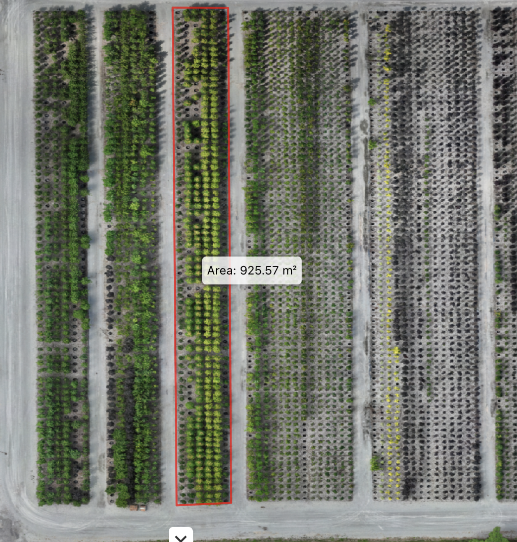
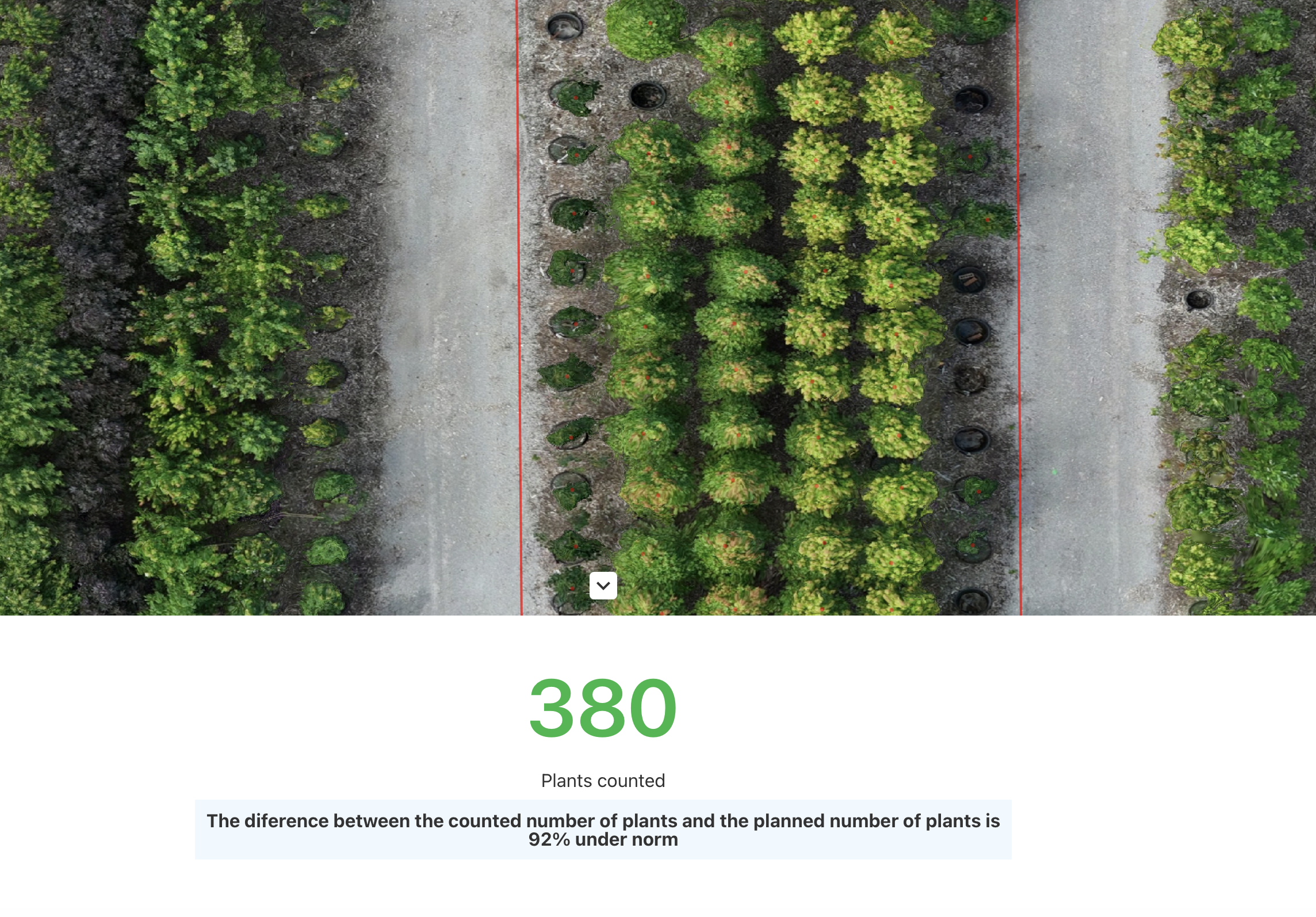
Using drone imagery or high-res scans, we tally plants automatically with 98%+ precision.
No more manual row-by-row checks; get pixel-perfect counts for roses, veggies, or ornamentals across greenhouses or fields.
Automatically get plant counts and plant health reports. Find out how many plants you have ready to ship and how many you have picked.
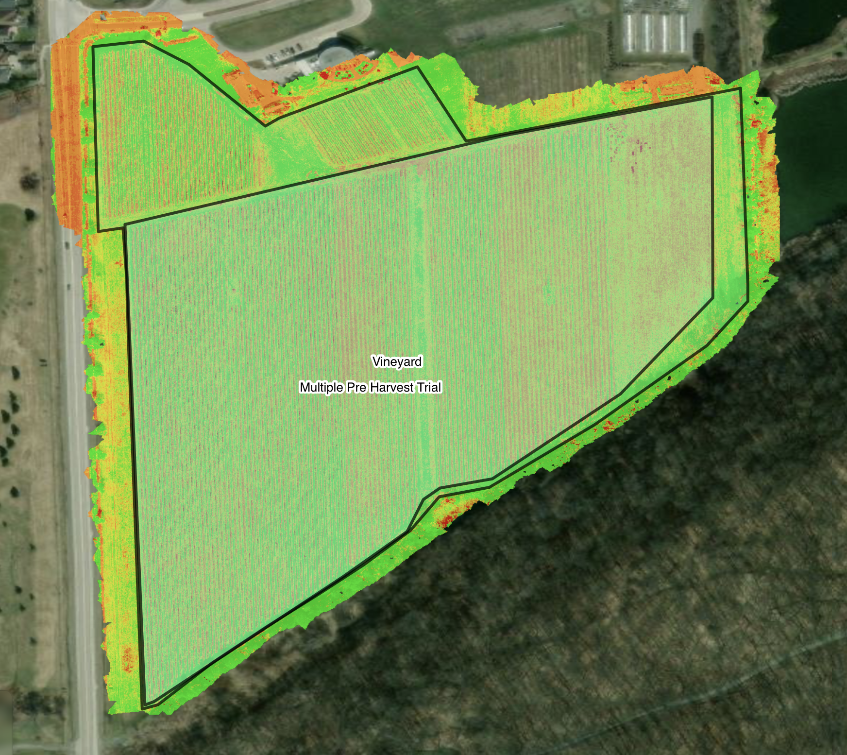
NDVI data shows you exactly how healthy and vigorous your plants are, right down to weak spots in your fields or greenhouses.
Pinpoint nutrient deficiencies or water stress for targeted fixes.
Monitor growth uniformity to boost yields and cut waste.
Track trends over time for smarter planting and harvesting decisions.